Explore Cowal

"Take nothing but pictures…leave nothing but footprints..kill nothing but time".

  • ‘Route Cards’
  • .Cowal
  • Bike Cowal
  • Kayak / Canoe Cowal
  • Walking Cowal
  • Wild Camp Cowal
  • ‘Useful Links’

Cowal Coastal 135. 

Posted by explorecowal on January 12, 2014
Posted in: Paddling. Tagged: coast, Cowal, paddle. 3 Comments

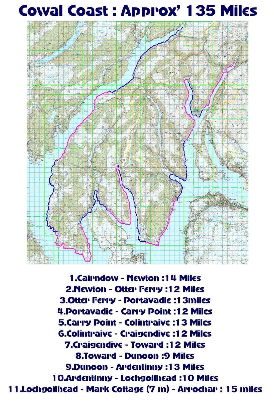
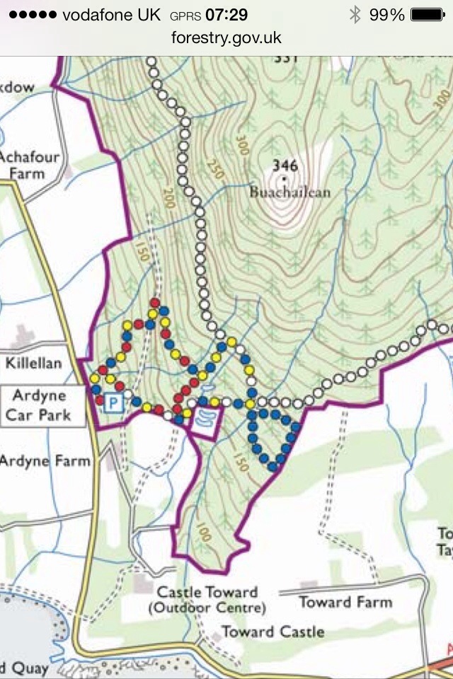
With an approximate total of 135 miles, the Cowal coast line offers plenty to explore.

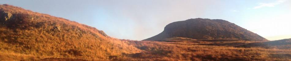
Taking in Loch Fyne, Kyles of Bute, Loch Ruel,Loch Riddon, Loch Striven, Firth of Clyde, Holy Loch, Loch Long and Loch Goil with the ever changing scenery. 

The route can be paddled either one section at a time or multiple sections. A moderate enjoyable paddle allowing time to explore and stop for breaks etc, not a mile munching time trial !

Each section starts/finishes close to a road so vehicle drop off and launch/up lift is easier.
If desired on multiple sections, wild camping, campsite camping, a bunk house, a bothy and even hotels can be found en route. Some village stops are available ,offering the chance to stock up on provisions. Please see below listings for Accommodation, Eateries, General Stores for supplies and Points of Interest. Most of these are where your kayak would hardly need to leave your sight. 

20140112-104308.jpg

Listings. 

Section 1-2

-Cairndow Stagecoach Inn. Food, Accommodation. http://www.cairndowinn.com

-Creggans Inn. Food,Accommodation http://www.creggans-inn.co.uk
-Out of the Blue Bistro/Post office.
Food,general store, post office.

Section 2-3

-Lachlan Bay,Old Castle Lachlan. POI http://www.oldcastlelachlan.com
-Inver Cottage. Food http://inverrestaurant.co.uk
-Oyster Catcher, Otterferry. Food. Accommodation. http://www.theoystercatcher.co.uk

Section 3-4-5. 

-Black Harbour. South of Otter Ferry. POI, Rocky Islands. Scenic. 

-Eilean Buidhe.  POI. Most Westerly part of Cowal. 

-Portavadie Marina. Food Accommodation. Shops http://www.portavadie.com

-Ascog Bay. POI. Scenic.  

-Kilbride Bay. POI. Scenic. 

-Ardlamont Point. POI. Most southerly point in Cowal. 

-Carry Farm, accommodation. Camping. http://www.carryfarm.co.uk

Section 5-6

-Kames Hotel. Food Accommodation
http://kames-hotel.com

-Duncan’s Stores. General store. Uphill from Kames Hotel. http://www.duncansvillagestore.co.uk

-Tighnabruaich, town. (RNLI slipway) access to…..
-Local Cafe. Food
-Spar. Grocery Store
-Various other outlets.
-Caladh Harbour. POI scenic
-Buttock Point,North Bute POI, Kayak stop.

-Burnt Islands,Kyles of Bute. POI. Scenic, tidal race! 

-Colintraive Hotel. Food Accommodation. http://www.colintraivehotel.com

Section 6-7. 

–Toward Sailing Club. POI. Kayak stop. http://www.towardsc.org.uk

-Toward Lighthouse. POI. Scenic. 

Section 8-9. 

-Innellan Slipway, North of Old Pier. Access to….
-Innellan Post Office and store.
-The Osbourne Hotel,Innellan. Food
-The Villagers Royal, Innellan. Food. http://villagers-royal.co.uk
-West Bay, Dunoon. Beach. Access to…..
-Cosy Corner,Food
-Rock Cafe,Food https://m.facebook.com/pages/Rock-Cafe-/128819720575851
-Coast Coffee. Food.
-Various Guest houses.
-Dunoon Town, Slipway at swimming pool. Access to…
-Town Centre. Shops
-Seasons Coffee shop. Food http://www.seasons.coffee

Section 9-10

-Kirn Beach,access to…..
-Kirn Variety Store, Groceries.
-Java Walk, Cafe
-Blacks the Bakers,Food.
-Other eateries.

-Slipway north of Western Ferries link span. Access to……
-Coffee Ahoy. Drinks. Snacks.
-Hunters Quay Hotel. Food , Accommodation http://www.huntersquayhotel.co.uk
-Royal Marine Hotel. Food, Accommodation. http://www.royalmarinehotel.co.uk

-Holy Loch Marina. Access to…..
-Various outlets within Marina including Holy Loch Cafe Shop. http://www.holylochmarina.co.uk
-Also access to Sandbank Post Office. Groceries. ( main rd).

-Ardentinny Hotel. Ardentinny. Food Accommodation. ( Closed for refurb).

  Section 10-11. 

-Caravan Shop,Drimsynie Estate. Near Drimsynie House. Concrete Bridge. General Store. Off Licence.
-Lochgoilhead Post Office. General Store.
-Goil Inn. Food ,Accommodation.

-Mark Cottage. Open Bothy (MBA). Opposite Glenfinart Depot. http://www.mountainbothies.org.uk/bothy-details.asp?bothy_id=116

-Arrochar Hotel. Food Accommodation. http://www.bespokehotels.com/arrocharhotel
-Arrochar Village Shop. General Store.
-Arrochar Fish and Chips. Food
-Ben Arthur’s Bothy,Food. https://m.facebook.com/pages/Ben-Arthurs-Bothy/264888646788

55.933259 -4.906962

Happy New Year

Posted by explorecowal on January 1, 2014
Posted in: Uncategorized. Leave a comment

To one and all. Look at all these possible days for Exploring Cowal 🙂

20140101-110817.jpg

Merry Christmas to all.

Posted by explorecowal on December 23, 2013
Posted in: Uncategorized. Leave a comment

20131223-162351.jpg

Glenmassan and Garrachra Glen

Posted by explorecowal on December 9, 2013
Posted in: Biking, Walking. Tagged: biking, Cowal, glenmassan, walking. Leave a comment

A wee 6 mile cycle through Glen Massan and Garrachra Glen.

Didn’t get as far as intended due to the wind blown trees…..maybe next time !!! Left from the small car park beyond Stonefield Farm at the end of the surfaced road. An easy level cycle on forestry roads. Starting to harvest the trees at the top of the glen,wont be long till they’re planting again.
Plenty of scope for future camping ares 🙂

A stop on the way to car park was required to get a few quick pics of the waterfalls.

DSCF5301t [1600x1200]
DSCF5297t [1600x1200]
DSCF5294t [1600x1200]
DSCF5288t [1600x1200]
DSCF5287t [1600x1200]
DSCF5285t [1600x1200]
DSCF5279t [1600x1200]
DSCF5272t [1600x1200]
DSCF5269t [1600x1200]
DSCF5264t [1600x1200]
DSCF5261t [1600x1200]
DSCF5256t [1600x1200]
DSCF5254t [1600x1200]
DSCF5249t [1600x1200]
DSCF5243t [1600x1200]
DSCF5240t [1600x1200]

20131209-205500.jpg

20131209-205539.jpg

MBA Mark Cottage Bothy,Loch Long. Cowal

Posted by explorecowal on December 2, 2013
Posted in: Biking, Bothy, forestry commission, Paddling, Walking, wildcamp #microadventure. Tagged: biking, Bothy, Cottage, Cowal, Mark, MBA, paddling, walking. Leave a comment

01/12/13 A trip out for a look at Mark Cottage Bothy.A bothy owned and maintained by the MBA.

We set off from Ardgartan on a 7 mile cycle to Mark Cottage. The return was the route reversed, giving a good 14 mile trail ….enough for a Sunday morning. In the clearances there are great views of Loch Long, both North and South. Also en route to the Bothy, there are numerous road side waterfalls.

The reason for the visit was prompted by further plans to visit the Bothy by kayaking from Ardentinny. Suitable landing points were found close to the bothy and there’s enough fallen/dead timber lying about for that all important fire.
A great bothy, the first ‘real’ bothy I’ve visited. Well laid out and kept clean by previous visitors and maintained by the MBA.

Planing to go back with kayak, but prior to that a wee winter sleep over could be on the cards. Either biking or walking, no matter what way, it’d be worth the journey. 🙂

Fuel: Fallen timber in the area. 

Altitude : 12 mts

Bike friendly : 10/10

One of the roadside waterfalls
Waterfall 2
Visitors Book
Visitors Book
DSCF5175t [1600x1200]
Home from home
Accommodation
Fine choice
DSCF5164t [1600x1200]
Bothy
History
Bothy
View South
Bothy
Made it !
Interior
Residents
Residents
DSCF5135t [1600x1200]
DSCF5134t [1600x1200]
DSCF5131t [1600x1200]
DSCF5130t [1600x1200]
DSCF5124t [1600x1200]
Loch Long,North


20131204-230549.jpg

Two Glens Loop. Glenbranter.

Posted by explorecowal on November 23, 2013
Posted in: Biking, forestry commission, Walking. Tagged: biking, commission, forestry, glenbranter. 2 Comments

Approx. 11 miles
Duration. 2hrs on the move, plus stops .

Looking forward to getting out on my new purchase (well new to me) ,the bike was loaded into the back of the motor ready for an early start.
Headed for Glenbranter picking up Martin ‘Mears’ and his trusty stead en route. Parking beyond the FCS offices at the events car park it wasn’t long till we were on our way.

20131123-153642.jpg

Choosing to take the Blue route. The Glenshellish Loop, a route suitable for beginners and families, approx 7 miles long. An ideal choice since I’ve not been on a bike for 10 years!! However in addition to this the Glenbranter Glen was added, giving an additional 3-4 miles.

20131123-154335.jpg

Forestry Commission Blue route detail HERE

Heading towards Glenshellish Farm over the bridge and taking the road on the immediate right. The route is well marked by posts at junctions, it continues up the East side of the Glen. There is a picnic bench for a wee stop at 3 miles into the loop just prior to the Ford crossing. The return via the West side to Glenbranter was mostly downhill.

20131123-161104.jpg

20131123-161152.jpg

20131123-161226.jpg

20131123-161251.jpg

20131123-161321.jpg

20131123-161407.jpg
Before heading back into Glenbranter we took a sharp left followed by a long climb then a sharp right, heading to Glenbranter Glen. A road leads off this section downhill to the right, marked by both Red Route and Cowal Way markers.

20131123-161922.jpg

Again, at the bottom if the hill you follow the East side of the Glen on a less defined forestry road. Reaching the top of the Glen there’s a deep Ford to cross! We however went up stream, crossing at a shallower narrower section.

20131123-162438.jpg

20131123-162518.jpgSafely across

Once across, the going is not to bad. Another Ford in a dip must be crossed but at this time it had little water passing through it. The run back down the West side again, like Glenshellish was mostly downhill and good progress made.

20131123-163047.jpg

On the return we passed the Red Route again where the downhill section joins the road from the left. Continuing along the Red Route drops away to the right, unfortunately the lower section is closed for now due to wind blown trees. Beyond this a crossing where the roads meet lets we headed straight down the hill to the back of the Lauder car park, where we returned to the Events car park via a surfaced road.

I great cycle today, especially as a reintroduction to Mountain Biking.

Pics from the camera……..

20131127-231046.jpg

55.933435 -4.923736

Buachailean. Toward. Night walk reccy.

Posted by explorecowal on November 19, 2013
Posted in: forestry commission, Trig Point, Walking. Tagged: ardyne, buachailean, walk. Leave a comment

20131119-223916.jpg

Target set for Buachailean on Sunday morning I parked at the Forestry Commission car park. Heading off at 07.20 I followed the way marked trail. Firstly the red/yellow/ blue/white markers. Then onto the red markers,before joining the blue and yellow that takes you in to the forestry road ( White markers). Now from here I headed straight across the road heading on what I thought was a trail marked on the O/S map. However, whilst showing on the map any evidence of any path on the ground is pretty much non existent. The forest has been harvested leaving no clear route. I did however continue on over brash,stumps and heather till reaching the summit.

20131119-225847.jpg
Overlooking street lit Bute en route to Summit.

Was on the summit for 8am just in time for sun rise. Spent a wee while gettin some pics as the clouds developed along with the coastal mist.

20131119-230315.jpg

20131119-230400.jpg

20131119-230520.jpg

20131119-230553.jpg

20131119-230621.jpg

20131119-230755.jpg

20131119-230910.jpg

20131119-231055.jpg

Whilst taking pictures and walking about the summit I noticed a well defined path on the west side of hill. It lead down the a wall which ran downhill towards the forestry road………the route I should have taken instead of old non existent path!!

20131119-231700.jpg
From the wall looking back up to the summit.

I returned back to forestry road following the wall all the way. Taking pics looking back as this should have been the approach route.

20131119-231936.jpg

20131119-232004.jpg

20131119-232033.jpg
Someone has even made this hand navigation aid,Ha.

Once back on the forestry road I continued down to the Chinese Ponds.

20131119-232321.jpg
Right turn here.

20131119-232435.jpg
The ornamental bridges at the Chinese ponds.

From here I joined the track for my return to the car park.

Hopefully be back on a night walk soon for views over Bute. Should be a good one…….now I know the easy route !!! 🙂
Think it’s about 4.5kms all in so a good wee walk giving great views.

20131119-232926.jpg
Top section once off forestry road showing Blue wrong route,Red correct route!!

Night Walk. Kilbride Loop.

Posted by explorecowal on November 15, 2013
Posted in: forestry commission, Walking. Tagged: Kilbride, night, walk. 1 Comment

20131115-102120.jpg
Waymarkers: blue markers
Distance: 3.1miles (5km)
Time: allow 2 hours 15 minutes
A longer hike which climbs higher Waymarkers: blue markers
Distance: 3.1miles (5km)

A longer hike which climbs higher up Kilbride Hill, through a stand of tall conifers and alongside the rushing Berry Burn. As it emerges from the depths of the trees, a wide panoramic view opens up, across to Loch Long, Helensburgh, Dunoon and Inverkip.up Kilbride Hill, through a stand of tall conifers and alongside the rushing Berry Burn. As it emerges from the depths of the trees, a wide panoramic view opens up, across to Loch Long, Helensburgh, Dunoon and Inverkip.

After Saturdays night walk, interest was shown from fellow walkers so a mid week walk was on the cards. Kilbride Loop was chosen as an intro to night walking, remaining on forestry roads and hardcore paths. Providing enough elevation to allow some great views. We were joined by members of the Dunoon Hill Runners, who of course ran the route plus some additional kms thrown in. Setting off from FCS Kilbride car park we crossed each other’s paths a few times on route. Great to see so many people on the hill, the darkness held no one back!!

20131115-121543.jpg
In to the night

20131115-121718.jpg
View after first section from Forestry road.

20131115-122204.jpg

20131115-122259.jpg

A gradual climb on the second path brings you to the top of the path where it contours the ditch before heading back down. From here the Runners were at the summit of Kilbride Hill and starting their decent.

20131115-122519.jpg
Runners moving off the hill

20131115-122645.jpg
View from top of loop

From here it was follow the Blue markers down hill until you join the top forestry road, turning right to find the first section and return the car park. We met the Runners again as they took the longer route back following the forestry road to car park.

20131115-123333.jpg

20131115-123354.jpg
The mandatory ‘standing view’ shot. Ha

Before heading back down to the first forestry road to return to the car park there was time for a wee play with the cameras.
It’s meant to say Explore Cowal, Ha.

20131115-123809.jpg

20131115-124104.jpg

Thanks to all who joined me/attended. A great turn out. Great to see something going on in Cowal !!!
Also thanks to Ian Orr for contributing some pics from the night.

55.939850 -4.919772

Night Walk. Bishops Seat. 504mts.

Posted by explorecowal on November 10, 2013
Posted in: forestry commission, Walking. Tagged: Bishops, Cowal, Seat, walk. 1 Comment

Having come up with the idea a night walk would be something different, the forecast for Saturday prompted an outing.
Destination set for Bishops Seat, a local hill walked many times in all conditions …… but never in the dark.

Setting off from the FCS Kilbride car park I was joined by Martin,Jamie and Andy. We headed off up the forestry road, past the new road till we came to the next corner. From here it was down to the burn where a crossing is required. There’s enough prominent stones and a fallen tree to aid the crossing, helped by the fact the burn was low. Once over the burn you continue on the trodden path keeping the burn on your right till you cross it again. An easier crossing than the previous one. From here follow the track till you join the forestry road where you take a sharp left and continue till you spot the roadside cairn.

20131110-232701.jpg
First view over the second crossing.

20131110-233238.jpg
View over Dunoon to Gourock and beyond from track/forestry road junction.

From here you leave the road heading up through the trees. Bit of a maze due to wind blow but there is some marker tape to help guide you to the clear fire break.
Once in the break, you follow it till you come to a small burn where you turn right. There is the remainder of a hardcore path which takes you to a wee bridge. Once across it’s out the trees and on to the open hill. A feint path leads the way to the summit,a gradual climb that not to harsh.

20131110-234010.jpg
View from the Summit towards Glasgow.

20131110-234124.jpg
Bishops Seat trig point and Plough

After a brief stop for pics (most never turned out due to misting of the lens due to the ‘fresh’ conditions!! ) and a drink it was time to head back. Returning to the forestry road in no time.

20131110-234600.jpg
View on returning to forestry road

Back to the car park we went having really enjoyed our night walk. Best thing is we’ll need to go back and get the group summit shot !!!!!!

Cheers.

20131111-001226.jpg

55.940914 -4.922325

Creag Sgoilte plane crash

Posted by explorecowal on November 2, 2013
Posted in: Uncategorized, Walking. Tagged: Cowal, crash, plane, strachur. Leave a comment

A few pics from a walk a while back. One of two crash sites at the back of Strachur.

Full walk detail

It was a Grumman Martlet. Think it was also known as the Wildcat,crashed in 1940.

20131102-123149.jpg

20131102-123202.jpg

55.921935 -4.919142

Posts navigation

← Older Entries
Newer Entries →
  • Recent Posts

    • YouTube
    • North West Loch Striven from B836
    • Strachur, Hill Lochs and Waterfalls. Scotways routes 97 and 98.
    • Cnocan Sgeir’e Trig point – Glendaruel
    • Cruach nan Capull Trig @565mts, St Catherine’s/Cairndow
  • Topics

    • About
    • Bikepacking
    • Biking
    • Bothy
    • Cowal High Way
    • Cowal Way
    • Cowalfest
    • Family
    • forestry commission
    • Gear
    • Heritage Paths
    • Outwith Cowal
    • Paddling
    • SIB
    • Trig Point
    • Uncategorized
    • Viewranger
    • Walking
    • wildcamp #microadventure
  • Blog Stats

    • 213,455 hits
  • Contact

    explorecowal@gmail.com
Blog at WordPress.com.
Explore Cowal
Blog at WordPress.com.
  • Subscribe Subscribed
    • Explore Cowal
    • Join 53 other subscribers
    • Already have a WordPress.com account? Log in now.
    • Explore Cowal
    • Subscribe Subscribed
    • Sign up
    • Log in
    • Report this content
    • View site in Reader
    • Manage subscriptions
    • Collapse this bar
 

Loading Comments...