
Cowal
All posts tagged Cowal
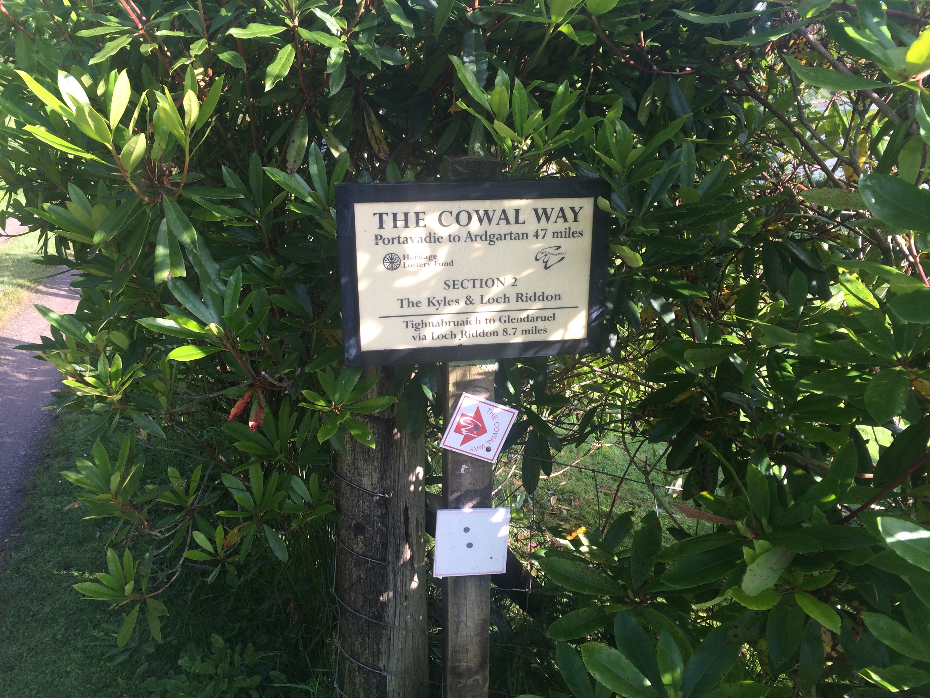
Firstly,what is the Coway Way?
Taken from the Cowal Way’s Website
“The Cowal Way in Argyll is known as “Scotland in 57 miles”. Only one to two hours from Glasgow and Prestwick International airports, this accessible part of the Scottish Highlands offers beautiful coastlines, dramatic scenery, engaging heritage and abundant wildlife.
The Cowal Way is Scotland’s most diverse long distance footpath. It runs the length of the Cowal Peninsula, passing through some of the most beautiful and varied landscape in the Highlands. The Cowal Way begins in the south of Cowal at Portavadie and winds its way up through the peninsula to end at Inveruglas on the shores of Loch Lomond, passing through the communities of Tighnabruaich, Glendaruel, Strachur, Lochgoilhead and Arrochar. The route makes use of existing footpaths, forestry tracks, hillsides, quiet roads and traditional rights of way. The terrain is varied and stimulating, encompassing forests, shorelines, hills and lochs.
A quiet and superb long-distance walk, it connects with the West Highland Way and also Kintyre Way.”

The Cowal Way is something that has been on my list of things to do, but just never had the time. In fact I still have a copy of the original book with the shorter route,the addition being the end point is now Inveruglas, Loch Lomond as supposed to Arrochar.
Apart from wanting to do this trail,an incentive was an opportunity to raise some funds for my wife’s highland dancing school. The sponsorship money going towards funding for pupils to compete in a competition in Disneyland,Paris.
Initially I did some research into the route,reading information on the Cowal Way website and a few reports on walking the route over 3-4 days. My mind was made up, something I could do that was right on my doorstep! However, once I started plotting my route I had roughly worked out that 80% of the route could be cycled,leaving the remaining 20% would involve pushing or carrying the trusty steed over the rougher,steeper terrain. On completion of the route I think the percentage is now split 70/30 as some sections are too steep or of varied terrain to use peddle power. Anyway, with my rough calculations I decided in my wisdom that this could be done in a day…….all be it, a long day !!! To be honest I did doubt myself, so as a precaution I decided to leave my camping gear with Argyll Voyageur Canoes in Lochgoilhead just in case.
Prior to committing to this journey I got in touch with Stewart ( Cowal Way Manager ) and Charlie ( Cowal Way Ranger ) to check on the areas of concern I had. These concerns were promptly cast aside with their encouraging words, ” a bike….a day, go for it ! “. As far as I’m aware someone has taken their bike on this walk, not quite sure if it was part or whole of the route, but certainly not in a day. Hello incentive number three.
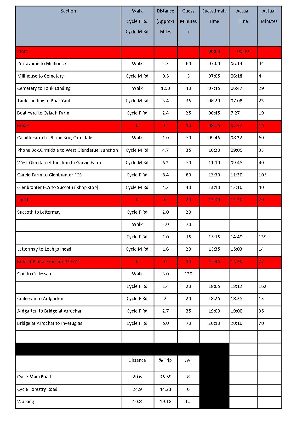
Please see below for my planning of sections,expected terrain and approximate times. This was basically to give an indication if there would be enough hours of daylight,hence the nice early start.
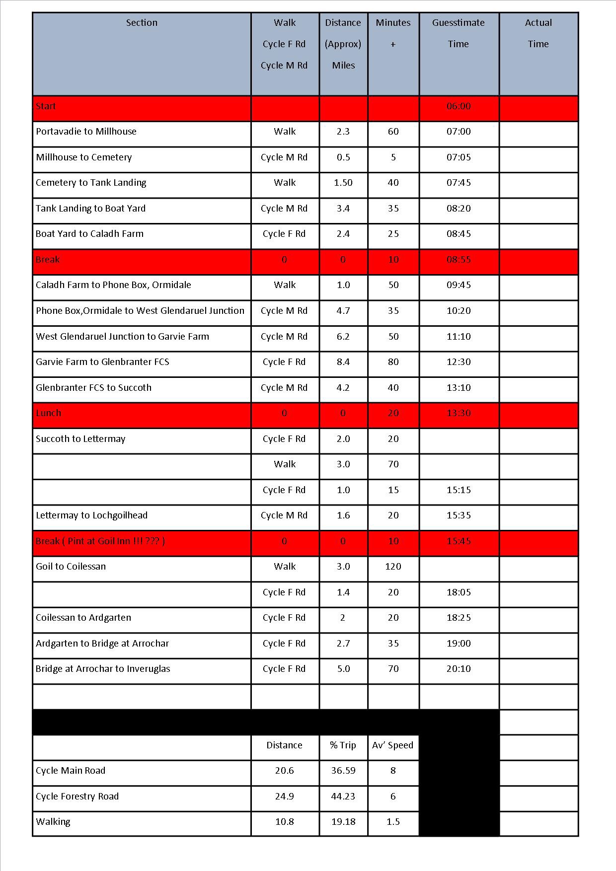
With my recent communication with the Cowal Way team I was kindly offered a lift to the start point, this was great as the alternative was to camp the night before at Portavadie. Charlie was at the end of my lane waiting to throw my bike in the back of his pickup truck at 04:15hrs, now that’s service.
Portavadie to Millhouse
Leaving from the slipway at the Portavadie ferry,before taking to the forestry road and then onto the off road trail. I’d noted this down as a walking section,however on some sections the bike can be used,especially from the eastern side of Loch Ascog out to the B8000 rural road. Path slightly overgrown in some very short sections, navigation easy enough following trail and marker posts.
")
")
")
")
")
")
")
")
")
")
Millhouse to Cemetery
A short main road cycle on rural public road. Gate with Stile for access to next off road section.

Cemetery to Tank Landing
Another section of off road,marked down as a walking section. Once over the Stile,progress is made initially over soft ground prior to firmer ground then cutting across golf course,before descending on a good bit of single track…perfect for the bike.
")
")
")
")
")
")
")
")
Tank Landing to Boatyard.
An uneventful and easy section along a rural paved road, good chance to get a few quick miles in. Passing through Kames and Tighnabruaich offers the opportunity for a toilet stop or stock up on supplies ( if it wasn’t so early,Ha).
")
")
")
")
Boatyard to Caladh Farm
A forestry road section, ideal for the bike. A few short sharp climbs but nothing to bad,progress good. Passing Caladh Estate and a few cottages before arriving at the path to shore.
")
")
")
")
Caladh Farm to Ormidale
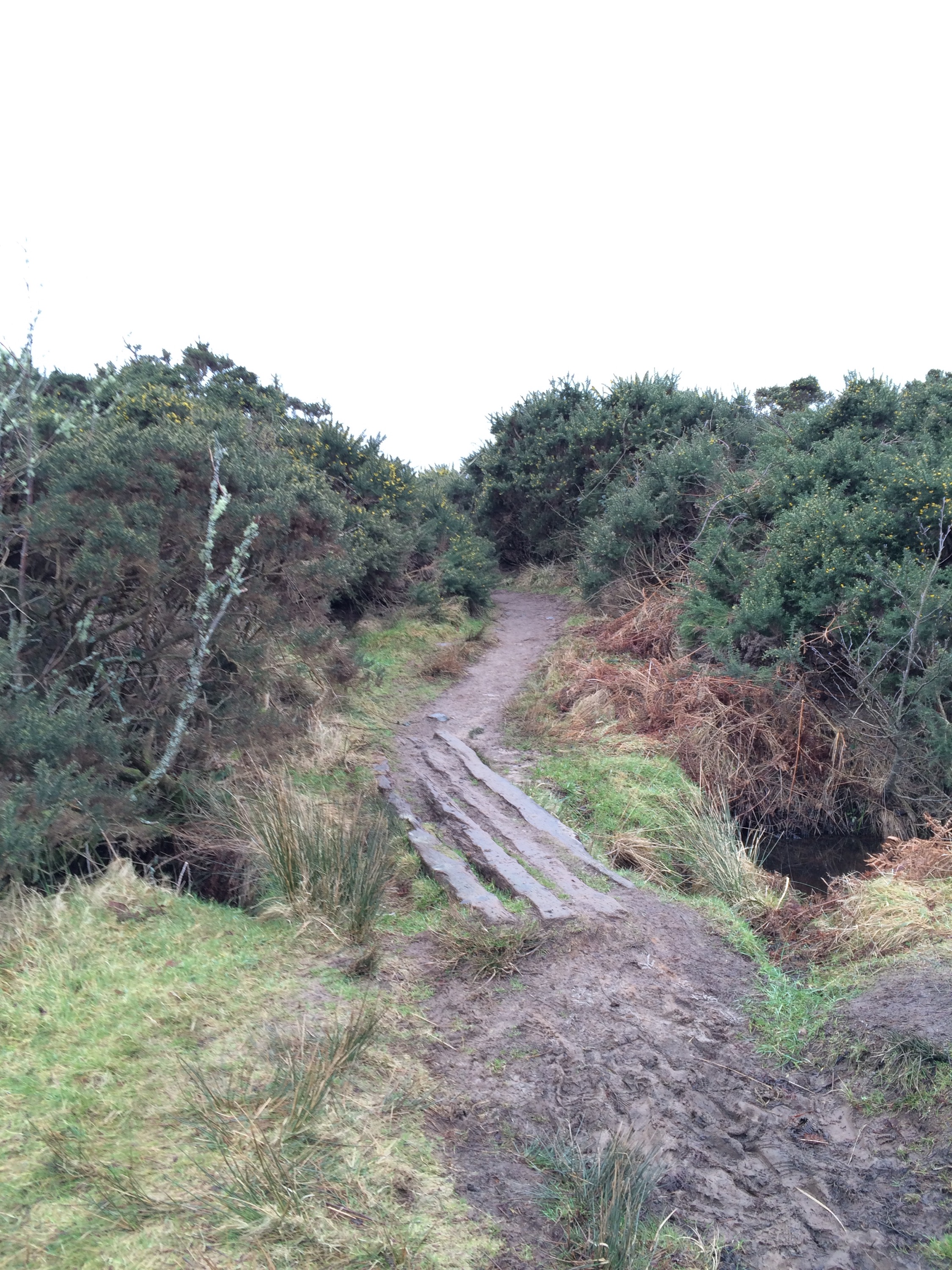
One of the area I had concerns with. Definitely a walk with pushing/lifting of the bike required,slow progress….but still progress. Shore walk prior to winding through the rocky woodland joining the public road at Ormidale Lodge. Improvement works are currently ongoing in this section. Walkways are being installed at the more difficult sections along with clearing and upgrading of the trail. It was wet underfoot but after the summer we’ve had it’s to be expected. Thankfully I’d allowed an hour for this section, the bike certainly impedes progress. It’s well documented that a low tide is beneficial whilst doing this section,especially with the bike. It gives the option of going round the large rocks on the shore as supposed to passing through them.
Certainly worked up a sweat on this section!
")
")
")
")
")
")
")
")
")
")
")
")
")
")
")
")
")
Ormidale to Glendaruel
Another straightforward cycle section. Rural paved road,passing Shellfield Farm before joining the A8003. Heading North turning off at Waulkmill and onto the old road that leads to the C11. Then it’s onto to the A886 for a short section,turning left for the Clachan of Glendaruel. Again progress good.
")
")
")
")
Glendaruel to Garvie Farm
Yet another straightforward section on a rural public road,another chance to get the miles in at a reasonable pace.
")
")
")
")
")
Garvie Farm to Glenbranter FCS
After a good few miles on public roads,the journey over to Glenbranter was on forestry road,approximately 8 miles. What I wasn’t counting on was the continuous climb of about 5 miles. Whilst not steep and more of a gradual climb over a long period the thighs were certainly feeling it, to the point I had to get off and push just to break the monotony and rest the thighs. The thought I wasn’t quite half way through my journey had me questioning what I was doing. What goes up must come down, the 3 mile descent into Glenbranter was a relief. Some of the time I’d gained on the previous sections had taken a hit, I was 25 minutes overdue. A wee pit stop at the FCS workshop for a drop of oil for an annoying click coming from one of my pedals,thankfully nothing serious.
")
")
")
")
")
")
")
")
")
")
")
")
")
")
")
")
Glenbranter FCS to Succoth.
Back on to the tarmac for this easy section. The quite, tree lined back road gave shelter from the sun. Feeling a lot better than 4 miles ago and heading for the petrol station to pick up something to eat and replenish the stock of fluids. A non eventual continuation to the end of the public road at Succoth.
Succoth to Lettermay
A mixed section of forestry roads and mid section of open hill. Starting this route on the forestry road was hard work,first a climb then onto a surface covered in brash from previous forest harvesting. Was down to such a speed walking would have been easier and less energy consuming, so a push through the rough section was the choice. The sun splitting the sky and the feeling I was going to internally combust meant a shaded area was sought for a bite to eat.
Fed and watered,it was time to hit the open hillside where the track terminates. This section requires a push all the way until joining the next forestry road. White marker posts make navigation easy as they provide a guide towards the lochain. If there was anything to deviate from the thought of my aching thighs it’s a peddle across the shin, then off my calf. Pushing the bike over the varied terrain wasn’t the best and the descent below the waterfalls may have made me swear out loud…….apologies to anyone climbing Beinn Bheula. The waterfalls are spectacular though!
Finally getting to the forestry road was a relief,followed by a speedy descent to Lettermay.
")
")
")
")
")
")
")
")
")
")
")
")
")
")
")
")
")
")
")
Lettermay to Lochgoilhead
Simple public road section into Lochgoilhead. A wee stop off at the shop at the caravan park for more fluid supplies before a break in the village. It was make or break time,chuck it for the day and go get the tent or push on to the end. Phoned Charlie to give him an update on progress then decided to continue on my merry way!
Lochgoilhead to Coilessan.
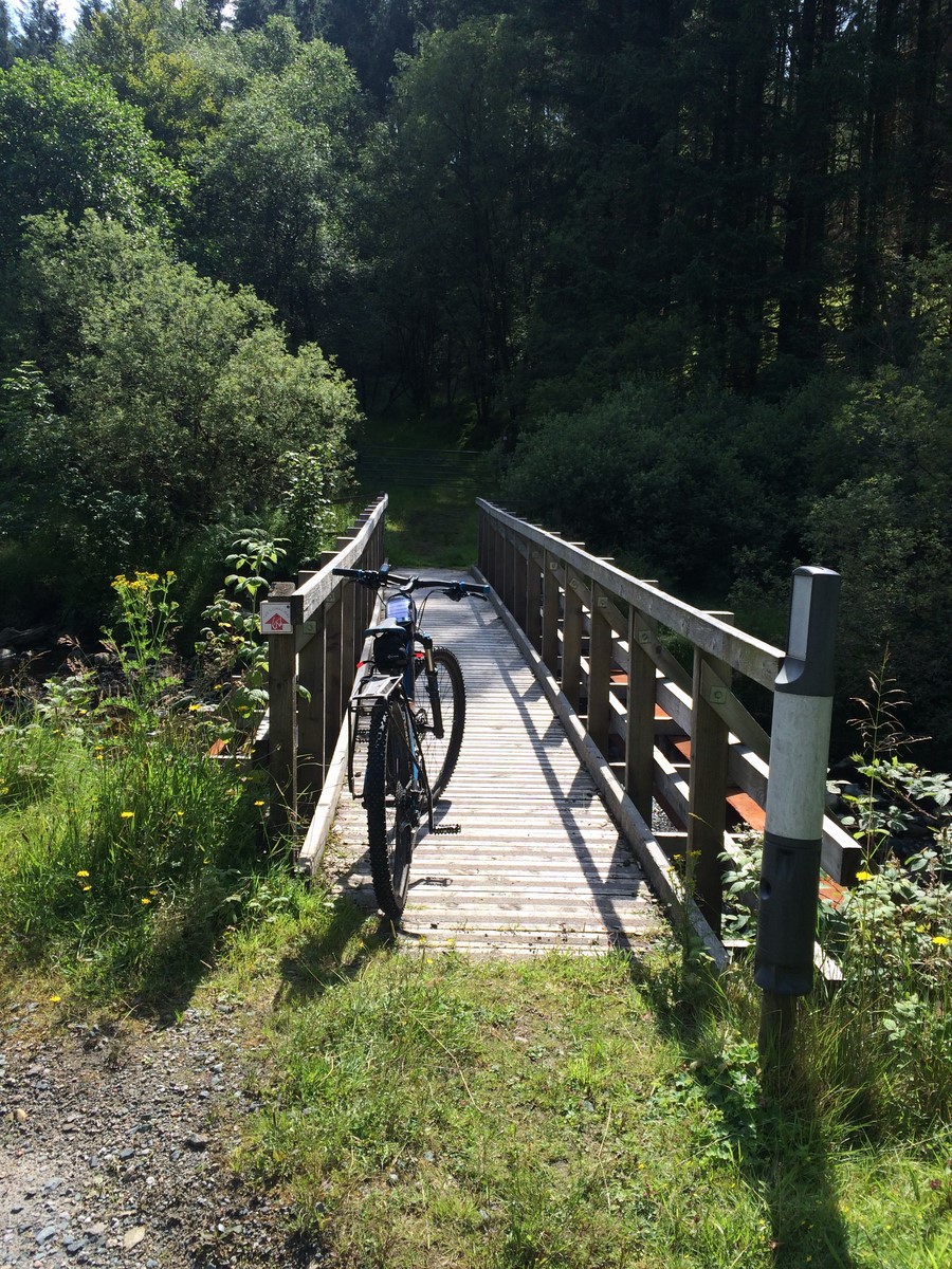
Now,seeing the hill I had to scale from the previous Strachur to Lettermay section I knew there was quite a climb ahead. I’d had a wee reccy of the lower part of this section before,so knew the terrain ahead……to a certain point. Pushed the bike from the car park to the second forestry gate. Once the bike was over the stile, a cycle to the waterfalls and bridge was an energy saver. The path from the bridge uphill required an initial push,then a cycle then a push. At the end of the track there is a steep,undulating slog ahead. Maybe I’m being a bit harsh, but after 40+ miles and having to carry or push the bike on this section was the worst thing I’ve ever done. Every 10 paces required a rest and the sweat was blinding. Once out the tree line the terrain was more favourable and slightly less steep. Marker posts are well positioned, cutting diagonally across the hill. It was a relief to actually see a marker post below me rather than above. Even managed a short cycle between a few of the posts before descending to a gate and steep hardcore track through the woods, sadly too steep to cycle. The track continued over a few small footbridges then it was time to get back on the saddle prior to joining a forestry road. The forestry road has suffered a great deal of wash out,there is some nice ruts and loose stone!! Joining the road at Coilessan car park, a nice smooth tarred surface.
")
")
")
")
")
")
")
")
")
")
")
")
")
")
")
")
")
")
Coilessan to Ardgaten
Leaving the Coilessan car park,it was a fast descent to Ardgarten on the surfaced road,even managed to get to 28mph!
")
")
Ardgarten to Bridge at Arrochar
Feeling good that there was only 7 miles to go and the end was nigh. Crossing the A83 at the designated point, the track wound it’s way up to join a forestry road. This was mostly a push as too steep to cycle. Once on the forestry road, which was mostly level,allowed a bit of pace before descending the zig-zags towards Succoth car park on the A83. A short section to the head of the loch turning left just after the bridge.
")
")
Arrochar to Inveruglas
The home straight ( with some bends,ascents and descents). 5 miles to go !!!!!!!!!!!! Off to a great start on the final section. Wide forestry road followed my a wide path allowing good progress, following the power pylons through Glenloin. Half way through the glen,the track becomes too steep and eroded to cycle. So it’s back to pushing till the highest point at the foot of one of the pylons. From here its a great descent on a good track. Crossing Inveruglas Water, it’s onto the main road for the hydro operations, a tarred surface makes for a speedy descent to the main road and onto the cafe at Inveruglas !!!
THE END !!!!
")
")
")
")
")
")
")
The Finishing point. 57 miles and 14.5hrs later !!!!!!!!!!


If that’s not enough info, there’s an INTERACTIVE MAP WITH PICTURES AVAILABLE BY CLICKING HERE
Huge thanks to all those that sponsored me, your generosity is much appreciated. Thanks also to Charlie and Stewart at The Cowal Way for their input and support. Special thanks to my wife and daughter for coming to pick me up, didn’t fancy the cycle back!!


It might be like watching paint dry but you will be able to track my progress as I undertake the Cowal Way ( signal dependant) via Viewranger.
Hopefully this Thursday.
Updates should be every 5 minutes or so , starting approx’ 06:00hrs Thursday the 13th August.
Link will be posted on Explore Cowal’s Facebook and Twitter pages as I’m ready to set off.
Click HERE to take you to my tracking page.
Thanks.
…..completing the Cowal Way. Sometime before the end of August, possibly this week as the forecast is looking good!
Well hopefully within the next two weeks I’ll be undertaking completion of the Cowal Way. To be honest, towards the end of this week is looking promising.
Had originally planned to do this in a day but I don’t want to let people down, so to be safe I’m saying two days, however I will try my best to do it in one day as originally planned.
Of course there is an added incentive to doing this other than the Cowal Way is on my list of ‘things to do’. My wife is fundraising to help pupils of her Highland Dancing School attend the International Gathering of Highland Dance in Disneyland, Paris 2015.
So if your feeling flush and can spare a few £’s ,donations are more than welcome. Only payment other than cash or cheque is via PayPal to smiffysmc@btinternet.com
I can also be contacted on explorecowal@gmail.com
Many Thanks,
Fraser.
As there are sections on public and forestry roads I’m intending on taking my mountain bike, this would allow me to get the miles in. However there are sections that I’d not be able to cycle due to terrain or steepness. So a push or a carry of my bike would be required and probably more of an inconvenience than anything for the off road sections.
Of course there is an added incentive to doing this other than the Cowal Way is on my list of ‘things to do’. My wife is fundraising to help pupils of her Highland Dancing School attend the International Gathering of Highland Dance in Disneyland, Paris 2015.
A great opportunity for the kids and any contribution to reducing the cost of the trip would be greatly welcomed.

If wish, you can donate via PayPal to smiffysmc@btinternet.com or contact me at explorecowal@gmail.com for further methods.
A morning trip to Buachalean,Toward.Taking advantage of the clear dry mornings,an early start so i could get back for work.
Leaving from the FCS car park at Ardyne,turning right once on the first trail and following it as it passes over an overgrown forestry road. Looking back the view over towards Bute already opening up. Continuing straight up the trail ingnoring any others that lead off,soon joins a forestry road. A left turn is required then a right turn leaving the road for an ATV track. The ATV track is defined and soon follows a wall to the base of the hill. A hole in the wall leads to a track that leads straight up the hillside to the summit. The views to the South over Bute and Arran make the trip well worth it.
On the return, a visit to the Chinese Ponds is a must. Situated on the left once descending from the top forestry road.
")
")
")
")
")
")
")
")
")
")
")
")
")
")
")
")
")
")
An interactive map with pictures and stats is available by clicking HERE
Summit 360 degree video

On a recent walk I discovered Heritage Paths. There are a number of these within Cowal.
Heritage Paths..“Heritage paths are old routes that have been used for a specific purpose, examples include:
Roman roads
Drove roads
Pilgrimage routes
Miners’ paths
Trading paths
Military roads
Turnpike roads
Shieling paths ”
Paths local to Cowal are:-
– Glenstriven to Ardtaraig , Loch Striven. 7.5kms
– Old road through Strath Eachaig, Pucks Glen to Benmore Gardens. 1.7kms
– Lochgoilhead carriage road, Bridge to Bridge adjacent to the B839. 3.25kms.
– The Dukes Pass, Lochgoilhead to Mark Cottage, Loch Long. 9.5kms.
More information on the paths click…Heritage Paths
My reports on the walks ( updated as I complete them ). Click on route name for information.

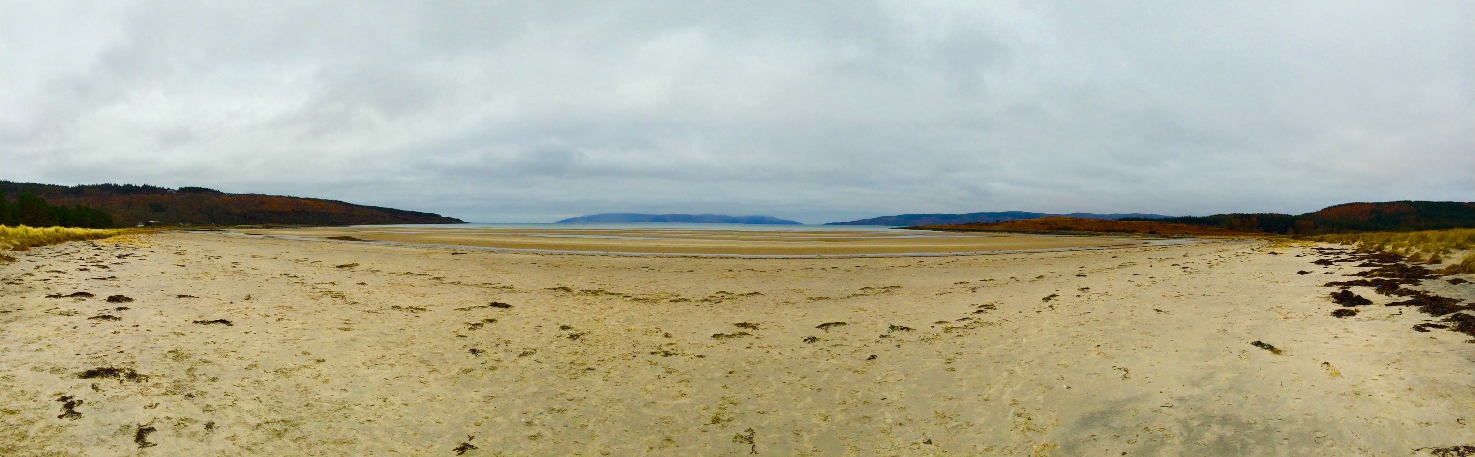
In summer time this place is always busy,but in winter most tend to forget about it.
At just under a miles walk from the roadside, there’s no excuse not to visit this gem of a beach.
Navigation isn’t a problem as it’s well signed and the defined path leads you to the beach.
A Golden beach with shallow waters, an ideal spot for some beach combing or a wee picnic with the family.


A snowy summit…………..
Well the whole journey was a tad wintery, including a rather ‘fresh’ Easterly wind !!
Planning ahead, I’d taken my bike to speed up the lower section from Benmore Gardens to where the forestry road ended and the hill track started. This would also speed up my return journey,the thought of free wheeling the final stage back to the car made the original climb past the view point seem worth it.
Once on the snow covered hill track,it was straight up hill to the fence line,some great view over Benmore,the Holy Loch and beyond were to be had. Over the first gate,continuing north till i found the old fence line,well the uprights were the only things visible. Once on the summit of A’Cruach (482mts) things got interesting, a snow filled,wind swept landscape awaited. Some drifts could not be avoided,the first one was fun as i waded through the thigh high snow…………after twenty similar scenarios the novelty had worn off !! Next was Creachan Beag (547mts) as i followed the fence line, the surrounding hills lit up by the sun. Ground conditions varied from,grassy tussocks,fields of ice and various depths of snow (mostly 12″ +), i certainly felt the strain on this walk. Onwards to Creachan Mor that towers above Coire nan Cleireach,this is where i left the fence line and headed NW to the summit of Clach Bheinn. Planning this route beforehand I’d picked out a route,however due to the drifts it was a case of dodging what i could and heading for any sign of solid ground. After zig-zagging and contouring round the hill the summit cairn was spotted, a welcome sight indeed. View from the true summit weren’t as good as i hoped,looking north was still obscured by adjacent rocky outcrops. But exploring the high tops in the prestent conditions was a no go.
The thought of returning via the same route had me planning a different descent. A south eastern walk down the shoulder heading for the tree line followed by a steep westerly down by the trees,the snow deep but at least it was all downhill and good progress made. I’d once hiked up a section of this large clearing many years ago so i knew what to expect. Eventually emerging onto the forestry road on west Loch Eck………solid even ground….. at last !
Something was always in the back of my mind……………..my bike !!! It was still hopefully sitting up beyond the Benmore viewpoint,aaaaargh. Perhaps taking it wasnt the best idea 🙂 A trudge back up the hill to fetch it, followed by the free wheeling section i’d been looking forward to before a slow pedal back to the car.
")
")
")
")
")
")
")
")
")
")
")
")
")
")
")
")
")
")
")
")
")
")
")
")
")
")
")
")
")
")
")
For an interactive map with route, stats and picture locations click HERE
Map

Will upload video once I get some decent tinternet connection!!
A giveaway bonanza!!! Your chance to add this beauty of a conversation starter to your kitchen cupboard.
YOU could be drinking from this very mug, sculpted from the finest Funky Pigeon clay (no pigeons harmed in the making of this mug) and emblazoned with an image from one of my walks.


All you need to do is ‘Like’ this on Facebook ( Explore Cowal) , ‘Favourite’ on Twitter (@explorecowal) or leave a comment on here to be entered into the prize draw.
The draw will take place on Sunday the 4th January 2015.
There is only one mug available, so prior to entering please ensure you are able to come to terms with the fact you may not win it.
Here’s to a great 2015. 👍🍻
Took a wee trip to Ardentinny to have a look about,an area I’m ashamed to admit I’ve never walked or cycled. Main objective was to look for an access route onto Creachan Mor,whilst i was there i decided to check out the ‘Knap Burn’ route, signed by the Forestry Commision.
Found an accesss to the hill via the pylons that cross the lower section of the hill,not ideal but once on the hill it’s easy enough to divert away from them.
Continuing on,I checked the GPS and a 5 mile route on forestry roads looked straight forward. Heading NE on the forestry road prior to heading down to ‘Raven’s Rock’ and down to Knap before returning on the lower road to the woodland walk. The section in the NE between the Upper and Lower road is more of an ATV track……….an overgrown one at that !! Doesn’t seem to have been much or any maintenance carried out in this section for a while,quite hard to spot the track from the top road.
There’s the reamians of a building at Knap,an ideal Bothy project!!! I had also noticed a sign at the FCS car park stating the Carrick trail was closed due to damage to the road……….they weren’t wrong !!!
")
")
")
")
")
")
")
")
")
")
")
")
")
")
")
")
")
")
")
")
")
")
")
")
")
")
")
")
Next time i return,it’ll be for a trip to Carrick and back or to conquer Creachan Mor.

