Explore Cowal

"Take nothing but pictures…leave nothing but footprints..kill nothing but time".

  • ‘Route Cards’
  • .Cowal
  • Bike Cowal
  • Kayak / Canoe Cowal
  • Walking Cowal
  • Wild Camp Cowal
  • ‘Useful Links’

Clach Bheinn, 643mts

Posted by explorecowal on January 20, 2015
Posted in: Walking. Tagged: bheinn, clach, Cowal, Snow, walk, walking, Winter. 5 Comments

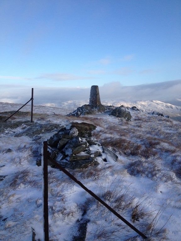
A snowy summit…………..

Well the whole journey was a tad wintery, including a rather ‘fresh’ Easterly wind !!

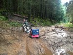
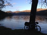
Planning ahead, I’d taken my bike to speed up the lower section from Benmore Gardens to where the forestry road ended and the hill track started. This would also speed up my return journey,the thought of free wheeling the final stage back to the car made the original climb past the view point seem worth it.

Once on the snow covered hill track,it was straight up hill to the fence line,some great view over Benmore,the Holy Loch and beyond were to be had.  Over the first gate,continuing north till i found the old fence line,well the uprights were the only things visible. Once on the summit of A’Cruach (482mts) things got interesting, a snow filled,wind swept landscape awaited. Some drifts could not be avoided,the first one was fun as i waded through the thigh high snow…………after twenty similar scenarios the novelty had worn off !! Next was Creachan Beag (547mts) as i followed the fence line, the surrounding hills lit up by the sun. Ground conditions varied from,grassy tussocks,fields of ice and various depths of snow (mostly 12″ +), i certainly felt the strain on this walk. Onwards to Creachan Mor that towers above Coire nan Cleireach,this is where i left the fence line and headed NW to the summit of Clach Bheinn. Planning this route beforehand I’d picked out a route,however due to the drifts it was a case of  dodging what i could and heading for any sign of solid ground. After zig-zagging and contouring round the hill the summit cairn was spotted, a welcome sight indeed. View from the true summit weren’t as good as i hoped,looking north was still obscured by adjacent rocky outcrops. But exploring the high tops in the prestent conditions was a no go.

The thought of returning via the same route had me planning a different descent. A south eastern walk down the shoulder heading for the tree line followed by a steep westerly down by the trees,the snow deep but at least it was all downhill and good progress made. I’d once hiked up a section of this large clearing many years ago so i knew what to expect. Eventually emerging onto the forestry road on west Loch Eck………solid even ground….. at last !

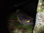
Something was always in the back of my mind……………..my bike !!! It was still hopefully sitting up beyond the Benmore viewpoint,aaaaargh. Perhaps taking it wasnt the best idea 🙂 A trudge back up the hill to fetch it, followed by the free wheeling section i’d been looking forward to before a slow pedal back to the car.

IMG_9246 (Copy)
IMG_9247 (Copy)
IMG_9248 (Copy)
IMG_9251 (Copy)
IMG_9252 (Copy)
IMG_9253 (Copy)
IMG_9254 (Copy)
IMG_9255 (Copy)
IMG_9256 (Copy)
IMG_9257 (Copy)
IMG_9258 (Copy)
IMG_9259 (Copy)
IMG_9260 (Copy)
IMG_9264 (Copy)
IMG_9267 (Copy)
IMG_9270 (Copy)
IMG_9274 (Copy)
IMG_9277 (Copy)
IMG_9279 (Copy)
IMG_9280 (Copy)
IMG_9281 (Copy)
IMG_9282 (Copy)
IMG_9283 (Copy)
IMG_9284 (Copy)
IMG_9285 (Copy)
IMG_9287 (Copy)
IMG_9293 (Copy)
IMG_9296 (Copy)
IMG_9298 (Copy)
IMG_9447 (Copy)
IMG_9448 (Copy)

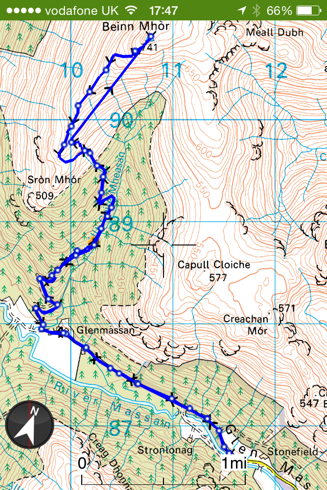
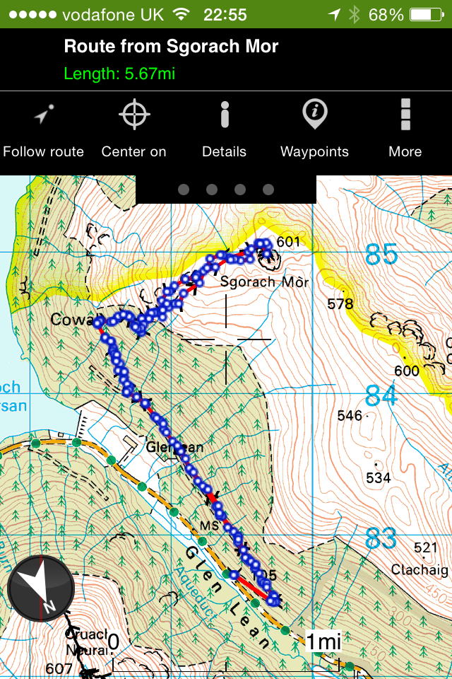
For an interactive map with route, stats and picture locations click HERE

Map

2015/01/img_9300.png

Will upload video once I get some decent tinternet connection!!

NW Loch Eck,Trig :- Bike and Hike.

Posted by explorecowal on December 30, 2014
Posted in: Biking, forestry commission, Trig Point, Walking. Tagged: biking, Eck, loch, Trig, walking, Winter. 2 Comments

Decided to try something different,a bike followed by a hike to get to this trig point.

IMG_9224

Parking at Glenbranter at the FCS car park, I headed off on the bike for the forestry road section. I’d found an ATV track by chance when descending from Beinn Bheag a good while back, so relocating this track for access to the hill was the next step. Remarkably I found the track, as if I was there yesterday, just as I remembered. The track too steep to cycle up, I pushed the bike the point of the washed out burn crossing then walked the remainder and onto the open hill. There’s a couple of splits in the track, two lefts and a right gets you onto the hill. The second left hand track was unknown to me as my descent on last trip came from the right, but the choice paid off.
The track took me out at the base of the hill, leaving a short and steep ascent to the trig, far easier than I thought it’d be.

Stunning views were to be had, snow covered hills and mountains all around, along with partial views over Loch Eck.
I remember seeing a mast at the top of this hill many years ago, but it had vanished and I never thought anything about it…….until I reached the summit. The control station still exists along with the dismantled mast, the internals of the station stripped out…..a good wee place to hide in extreme weather! Even if there’s no door.

After a wee wander about the tops I returned on the same route, picking up a frosty bike for the downhill return. I’m no mountain biker, mostly forestry roads but I enjoyed hanging of the back of the bike on the track section!! The forestry road hardly took a turn of the pedals to get back to the car, the quickest descent I’ve ever done!!!

Time saving and energy saving……it’s the future!!!! 😉

FCS Glenbranter office
-4.......nice.
Unloaded
Unloaded
Bridge before Glenshellish
Forestry road
Forestry road
IMG_9183 (Copy)
Turning left on to top road
Hill track
Hill track
Sun on opposite hills
Quad track
Quad track
Left here
Left here
Summit on left
Summit on left
IMG_9194 (Copy)
Abandoned bike here
Abandoned bike here
IMG_9197 (Copy)
Left here
Left here
IMG_9199 (Copy)
Follow track on right
Summit hill
Summit hill
Looking back
Looking back
IMG_9204 (Copy)
Grassy way,between rocks
IMG_9206 (Copy)
IMG_9207 (Copy)
IMG_9208 (Copy)
IMG_9209 (Copy)
First sight of Trig
First sight of Trig
IMG_9211 (Copy)
IMG_9212 (Copy)
IMG_9213 (Copy)
IMG_9214 (Copy)
IMG_9216 (Copy)
Old mast station
Old mast station
IMG_9218 (Copy)
IMG_9218
Lego man,gettin a picture
IMG_9220 (Copy)
IMG_9220
Loch Eck,Loch Long and beyond
IMG_9222 (Copy)
IMG_9223 (Copy)
IMG_9223
IMG_9224 (Copy)
IMG_9224
IMG_9225
Frozen bike on return

Interactive map and pictures HERE

Location map below.

/home/wpcom/public_html/wp-content/blogs.dir/112/58341042/files/2014/12/img_9241.png

Free to a loving home…..

Posted by explorecowal on December 29, 2014
Posted in: Uncategorized. Tagged: Cowal, Eck, free, loch, mug. Leave a comment

A giveaway bonanza!!! Your chance to add this beauty of a conversation starter to your kitchen cupboard.

YOU could be drinking from this very mug, sculpted from the finest Funky Pigeon clay (no pigeons harmed in the making of this mug) and emblazoned with an image from one of my walks.

/home/wpcom/public_html/wp-content/blogs.dir/112/58341042/files/2014/12/img_9237.jpg

/home/wpcom/public_html/wp-content/blogs.dir/112/58341042/files/2014/12/img_9239.jpg

All you need to do is ‘Like’ this on Facebook ( Explore Cowal) , ‘Favourite’ on Twitter (@explorecowal) or leave a comment on here to be entered into the prize draw.

The draw will take place on Sunday the 4th January 2015.

There is only one mug available, so prior to entering please ensure you are able to come to terms with the fact you may not win it.

Here’s to a great 2015. 👍🍻

55.946075 -4.932164

Knap Burn,Ardentinny. **Closed- Taken Back by Nature**

Posted by explorecowal on December 27, 2014
Posted in: forestry commission, Walking. Tagged: Ardentinny, Burn, Cowal, Knap, walk, walking. Leave a comment

Took a wee trip to Ardentinny to have a look about,an area I’m ashamed to admit I’ve never walked or cycled. Main objective was to look for an access route onto Creachan Mor,whilst i was there i decided to check out the ‘Knap Burn’ route, signed by the Forestry Commision.

Found an accesss to the hill via the pylons that cross the lower section of the hill,not ideal but once on the hill it’s easy enough to divert away from them.

Continuing on,I checked the GPS and a 5 mile route on forestry roads looked straight forward. Heading NE on the forestry road prior to heading down to ‘Raven’s Rock’ and down to Knap before returning on the lower road to the woodland walk. The section in the NE between the Upper and Lower road is more of an ATV track……….an overgrown one at that !! Doesn’t seem to have been much or any maintenance carried out in this section for a while,quite hard to spot the track from the top road.

There’s the reamians of a building at Knap,an ideal Bothy project!!! I had also noticed a sign at the FCS car park stating the Carrick trail was closed due to damage to the road……….they weren’t wrong !!!

IMG_9142 (Copy)
IMG_9144 (Copy)
IMG_9145 (Copy)
IMG_9146 (Copy)
IMG_9147 (Copy)
IMG_9150 (Copy)
IMG_9151 (Copy)
IMG_9152 (Copy)
IMG_9153 (Copy)
IMG_9154 (Copy)
IMG_9155 (Copy)
IMG_9156 (Copy)
IMG_9157 (Copy)
IMG_9158 (Copy)
IMG_9159 (Copy)
IMG_9160 (Copy)
IMG_9161 (Copy)
IMG_9162 (Copy)
IMG_9163 (Copy)
IMG_9164 (Copy)
IMG_9165 (Copy)
IMG_9166 (Copy)
IMG_9167 (Copy)
IMG_9168 (Copy)
IMG_9169 (Copy)
IMG_9170 (Copy)
IMG_9171 (Copy)
IMG_9172 (Copy)
Map with pictures CLICK HERE

Next time i return,it’ll be for a trip to Carrick and back or to conquer Creachan Mor.

/home/wpcom/public_html/wp-content/blogs.dir/112/58341042/files/2014/12/img_9177.png

Beinn Ruadh, 644mts. A winters walk.

Posted by explorecowal on December 15, 2014
Posted in: Trig Point, Walking. Tagged: beinn, Cowal, route, ruadh, walking. 2 Comments

Although I’ve walked this hill before , I thought I’d try it from a different approach. Setting off from the FCS car park at Inverchapel,following the red route to the view point then leaving the hardcore track for the open hillside.

IMG_9016 (Copy)

I’m not going to lie……….the initial climb over the varied and steep terrain did have me taking a few picture opportunities ( breathers), my legs were paying the price of the constant climb. There is no path, so it’s pretty much do your own thing. I had an idea to follow fence lines but the steep rocky terrain put me off. I’d plotted a rough route,dodging the larger rocky outcrops,so that’s the route I took. Looking on a map and seeing what’s actually on the ground are two different things!! Zig-zagging up the hill I eventually got to the section where I could see the summit,the walk from here is quite straight forward. There are a number of old iron fence posts that guide you to the summit.
On the return, I decided to head out onto some of the outcrops to gain some great views over Loch Eck and the surrounding hills. I also decided to follow the fence line that took me back the the gate,mid hill. Thankfully I never took this route on the way up as the boulder strewn hill was not ideal walking terrain, especially with a dusting of snow. Some voids could take your leg !!

Despite the constant climb,it was a great way to do this hill. A great view was always had,more so with the hills topped with snow.

Below are all my pics (almost 100),I couldn’t bare to miss any out…………….well there is that dodgy ‘selfie’!!! Feel free to print it and it’ll keep the kids away from the fire !!

IMG_8966 (Copy)
IMG_8967 (Copy)
IMG_8968 (Copy)
IMG_8969 (Copy)
IMG_8970 (Copy)
IMG_8971 (Copy)
IMG_8972 (Copy)
IMG_8973 (Copy)
IMG_8974 (Copy)
IMG_8975 (Copy)
IMG_8976 (Copy)
IMG_8977 (Copy)
IMG_8978 (Copy)
IMG_8979 (Copy)
IMG_8980 (Copy)
IMG_8981 (Copy)
IMG_8982 (Copy)
IMG_8983 (Copy)
IMG_8984 (Copy)
IMG_8985 (Copy)
IMG_8986 (Copy)
IMG_8987 (Copy)
IMG_8988 (Copy)
IMG_8990 (Copy)
IMG_8991 (Copy)
IMG_8992 (Copy)
IMG_8993 (Copy)
IMG_8994 (Copy)
IMG_8995 (Copy)
IMG_8996 (Copy)
IMG_9001 (Copy)
IMG_9002 (Copy)
IMG_9003 (Copy)
IMG_9004 (Copy)
IMG_9005 (Copy)
IMG_9006 (Copy)
IMG_9007 (Copy)
IMG_9008 (Copy)
IMG_9009 (Copy)
IMG_9010 (Copy)
IMG_9011 (Copy)
IMG_9012 (Copy)
IMG_9013 (Copy)
IMG_9014 (Copy)
IMG_9015 (Copy)
IMG_9016 (Copy)
Beinn Ruadh Trig
IMG_9018 (Copy)
IMG_9019 (Copy)
IMG_9020 (Copy)
IMG_9021 (Copy)
IMG_9022 (Copy)
IMG_9023 (Copy)
IMG_9024 (Copy)
IMG_9028 (Copy)
IMG_9029 (Copy)
IMG_9030 (Copy)
IMG_9031 (Copy)
IMG_9032 (Copy)
IMG_9033 (Copy)
IMG_9035 (Copy)
IMG_9036 (Copy)
IMG_9037 (Copy)
IMG_9038 (Copy)
IMG_9039 (Copy)
IMG_9040 (Copy)
IMG_9041 (Copy)
IMG_9042 (Copy)
IMG_9043 (Copy)
IMG_9044 (Copy)
IMG_9045 (Copy)
IMG_9046 (Copy)
IMG_9047 (Copy)
IMG_9048 (Copy)
IMG_9049 (Copy)
IMG_9050 (Copy)
IMG_9056 (Copy)
IMG_9060 (Copy)
IMG_9061 (Copy)
IMG_9062 (Copy)
IMG_9064 (Copy)
IMG_9065 (Copy)
IMG_9066 (Copy)
IMG_9067 (Copy)
IMG_9068 (Copy)
IMG_9069 (Copy)
IMG_9070 (Copy)
IMG_9071 (Copy)

For interactive map and locations of pictures,click HERE

Sgorach Mor,Cowal. 601 mts.

Posted by explorecowal on November 30, 2014
Posted in: Walking. Tagged: Cowal, loch, mor, sgorach, tarsan, walk, walking. Leave a comment

A walk I’ve not done for a while, Sgorach Mor was on the cards after last weeks trip ti Beinn Mhor. An interesting hill,giving great 360 degree views ( weather permitting ) not forgetting the views over Loch Tarsan.

5.7 (ish) miles :- 3 hrs.

Starting off on forestry roads,then onto a quad track (wet in places) and onwards to the open hill. The open hill is strewn with large boulders to start with along with many rocky outcrops. The summit it’s self is found on top of a rocky mass knows as the ‘volcanic plug’ !! It looks daunting on the approach but as you contour to the left and get to the rear of the hill,an easy final ascent to the summit is found. No trig point on this one,but a well defined Cairn awaits.
I made it up just in time,the clag wasn’t long in closing in on the summit.

A point to worth noting is where you come out of the tree line. Sometimes it can be hard to retrace to find your exit from the hill. I’m pretty sure there’s another way onto this hill from the top track,it looks to come out to the open hill by the burn at top of the climb then follow the fence line to Sgorach Mor, I just stuck to what I found last time up there.

IMG_8843 (Copy)
IMG_8845 (Copy)
IMG_8846 (Copy)
IMG_8847 (Copy)
IMG_8848 (Copy)
IMG_8849 (Copy)
IMG_8850 (Copy)
IMG_8852 (Copy)
IMG_8853 (Copy)
IMG_8854 (Copy)
IMG_8855 (Copy)
IMG_8856 (Copy)
IMG_8857 (Copy)
IMG_8858 (Copy)
IMG_8859 (Copy)
IMG_8860 (Copy)
IMG_8861 (Copy)
IMG_8862 (Copy)
IMG_8863 (Copy)
IMG_8864 (Copy)
IMG_8865 (Copy)
IMG_8866 (Copy)
IMG_8867 (Copy)
IMG_8868 (Copy)
IMG_8869 (Copy)
IMG_8870 (Copy)
IMG_8871 (Copy)
IMG_8872 (Copy)
IMG_8873 (Copy)
IMG_8874 (Copy)
IMG_8875 (Copy)
IMG_8876 (Copy)
IMG_8877 (Copy)
IMG_8878 (Copy)
IMG_8879 (Copy)
IMG_8880 (Copy)
IMG_8882 (Copy)
IMG_8883 (Copy)
IMG_8884 (Copy)
IMG_8885 (Copy)
IMG_8886 (Copy)
IMG_8889 (Copy)
IMG_8890 (Copy)
IMG_8891 (Copy)
IMG_8892 (Copy)
IMG_8893 (Copy)
IMG_8894 (Copy)
IMG_8895 (Copy)
IMG_8897 (Copy)
IMG_8898 (Copy)
IMG_8899 (Copy)
IMG_8901 (Copy)
IMG_8902 (Copy)
IMG_8905 (Copy)
IMG_8906 (Copy)
IMG_8907 (Copy)
IMG_8908 (Copy)
IMG_8909 (Copy)
IMG_8910 (Copy)
IMG_8911 (Copy)
IMG_8912 (Copy)
IMG_8913 (Copy)
IMG_8915 (Copy)
IMG_8916 (Copy)
IMG_8917 (Copy)
IMG_8918 (Copy)
IMG_8919 (Copy)
IMG_8920 (Copy)
IMG_8921 (Copy)
IMG_8922 (Copy)

Map of Route.

IMG_8932.PNG

IMG_8934.PNG

Interactive map with pictures and stats, click HERE

Beinn Mhor,Cowal. 741mts.

Posted by explorecowal on November 24, 2014
Posted in: Trig Point, Walking. Tagged: beinn, Cowal, mhor. Leave a comment

A quick note,on a trip to Beinn Mhor,one of Cowal’s Graham’s.

I decided in my wisdom to start this walk nice and early………….06.20 on Sunday morning. Needless to say the ascent was done in the dark with the aid of a head torch,switching off as I headed out of the trees onto the open hillside.

Starting of from the small car park at the top of Glenmassan,up the forestry road till it branched of to the right just beyond the old sheep fank. From here following another forestry road as it winds its way up the hill and into to trees. Eventually the road is reduced to a quad track,this is well defined and easy to follow. Once out the trees and onto the open hill I followed the track over to the left, contouring round the bottom of the hill then finally onto the ridge. The quad track from here leads you right to the summit,an easy navigation on all accounts.

I’ll do this walk again,maybe in daylight and favourable conditions so I can get some decent pictures.

Below are some pics, mostly on the way down due to darkness on way up !! Gives a rough idea of the type of terrain covered. Even encountered my first snow shower of the season !!!

IMG_8710 - Copy (Copy)
IMG_8717 - Copy (Copy)
IMG_8726 - Copy (Copy)
IMG_8729 - Copy (Copy)
IMG_8738 - Copy (Copy)
IMG_8739 - Copy (Copy)
IMG_8740 - Copy (Copy)
IMG_8741 - Copy (Copy)
IMG_8745 - Copy (Copy)
IMG_8747 - Copy (Copy)
IMG_8749 - Copy (Copy)
IMG_8754 - Copy (Copy)
IMG_8760 - Copy (Copy)
IMG_8766 - Copy (Copy)
IMG_8768 - Copy (Copy)
IMG_8769 - Copy (Copy)
IMG_8770 - Copy (Copy)
IMG_8771 - Copy (Copy)
IMG_8773 - Copy (Copy)
IMG_8774 - Copy (Copy)
IMG_8775 - Copy (Copy)
IMG_8776 - Copy (Copy)
IMG_8777 - Copy (Copy)
IMG_8778 - Copy (Copy)
IMG_8779 - Copy (Copy)
IMG_8780 - Copy (Copy)
IMG_8781 - Copy (Copy)
IMG_8781 (Copy)
IMG_8782 (Copy)
IMG_8783 (Copy)
IMG_8784 (Copy)
IMG_8785 (Copy)
IMG_8786 (Copy)
IMG_8787 (Copy)

360 degree video from summit

The snow shower

For some reason the GPS paused when heading to the summit, hence the ‘ as the crow flys ‘ straight line to the summit. The return shows the route better. Following the quad track makes sure you’ll find the exit from open hill to forest.

IMG_8796.PNG

Toward’s Castles

Posted by explorecowal on November 12, 2014
Posted in: Family. Tagged: castle, Family, toward. Leave a comment

Family time. A spare few hours and looking for something to do that wasn’t the swing park!
A great wee walk through the ‘jungle’ to discover the old walk through bridge, the ruins of Toward Castle and the ‘new’ castle.
Not forgetting the mandatory play on the beach.

IMG_8275.JPG

IMG_8283.JPG

IMG_8287-0.JPG

IMG_8291-0.JPG

IMG_8293.JPG

IMG_8301.JPG

IMG_8598.PNG

55.946102 -4.932288

Scotland Outdoors magazine.

Posted by explorecowal on October 30, 2014
Posted in: Uncategorized. Tagged: magazine, outdoors, scotland. Leave a comment

Got my ‘Kayaking on Loch Eck’ picture published 👍

IMG_8486.JPG

IMG_8488.JPG

IMG_8485-0.JPG

55.946095 -4.932284

Camping, Bikepacking :- Stuck Farmhouse, Loch Eck

Posted by explorecowal on October 28, 2014
Posted in: Bikepacking, Gear, wildcamp #microadventure. Tagged: Camping, Eck, farmhouse, loch, stuck. Leave a comment

Letting the bike take the strain !!!

Having bought a rear rack and bike mounted luggage from eBay (combination of bargains) a while back, it was time to put it to full use.
Not quite sure what size the rear panniers are but I’m guessing 32-40lts combined, plenty of room for a night away……plus additional nights. Bar bag probably giving 3lts of space, enough for bridge camera and some other camera stuff.

Despite a balmy 7 degrees forecast decided to take my 4 season sleeping bag and my tent as supposed to bivi bag. Might as well let the bike take the strain and sleep out in comfort.

Loaded and ready for the bike.

IMG_8420.JPG

Destination, ruins of Stuck Farmhouse.

IMG_8422.PNG

Flooded roads and landslides but we made it…….


55.946100 -4.932332

Posts navigation

← Older Entries
Newer Entries →
  • Recent Posts

    • YouTube
    • North West Loch Striven from B836
    • Strachur, Hill Lochs and Waterfalls. Scotways routes 97 and 98.
    • Cnocan Sgeir’e Trig point – Glendaruel
    • Cruach nan Capull Trig @565mts, St Catherine’s/Cairndow
  • Topics

    • About
    • Bikepacking
    • Biking
    • Bothy
    • Cowal High Way
    • Cowal Way
    • Cowalfest
    • Family
    • forestry commission
    • Gear
    • Heritage Paths
    • Outwith Cowal
    • Paddling
    • SIB
    • Trig Point
    • Uncategorized
    • Viewranger
    • Walking
    • wildcamp #microadventure
  • Blog Stats

    • 213,396 hits
  • Contact

    explorecowal@gmail.com
Blog at WordPress.com.
Explore Cowal
Blog at WordPress.com.
  • Subscribe Subscribed
    • Explore Cowal
    • Join 53 other subscribers
    • Already have a WordPress.com account? Log in now.
    • Explore Cowal
    • Subscribe Subscribed
    • Sign up
    • Log in
    • Report this content
    • View site in Reader
    • Manage subscriptions
    • Collapse this bar
 

Loading Comments...