Fed up trying to break firewood like the Karate Kid, I decided a more elegant means must be available.
A hand axe that’s small and light enough to carry, 14″ (355mm) length and 640 gms seemed to fit the bill. Can also act as a hammer for that stubborn ground that won’t accept a tent peg to easily.
An Exped Synmat UL 7, the UL standing for Ultra Light and the 7 refers to the thickness of the mat. I managed to get away with the short version as I’m only wee , but there’s plenty of other options in the range.
The reason for this purchase is I’m trying to cut back on weight and bulk on what I carry on my back, kayak or panniers on the bike.
Size n weight for the 7 range
UL 7 S – 163 x 52 x 7cm, 410g
UL 7 M – 183 x 50 x 7cm, 460g
UL7 LW – 197 x 65 x 7cm, 590g
Prior to this purchase I used a Vango sleep mat ( twice) and this gave a great nights sleep and at 3 cm thick gave a bit of insulation too. But it was too bulky and weighty for my weight loss programme, so it had to go.
To give an idea of ‘packed size’ comparison of the two here’s a wee pic. Ok , the Exped is 20cm shorter but it’s 4cm thicker and 570gms lighter!!
Mat and additional dry bag.
I’ll update this thread is I use this new addition, hopefully in the next few weeks.
Route:Toward Hall to Glenbranter Forestry Office. Length: 26.2 miles 41.9 km Ascent: +1345m -1327m Naismith: 10h 38m (walking pace) Terrain : Forestry road and short sections of rural paved road.
I was looking to create a route similar in distance to the Loch Eck Loop, a route that isn’t weather dependent (lower level) or to difficult to navigate but still giving rewarding views. As always staying away from public roads as much as possible and making the route manageable in smaller sections if need be. The availability of public transport is always a bonus. The route can be either cycled or walked and tackled in either direction.
A scenic route, starting from Toward, South Cowal extending to Glenbranter,south of Strachur.
Leaving Toward,heading north, passing above Innellan and Dunoon enjoying view over the Firth of Clyde. Continuing through to Glenkin and on to Glenmassan, before heading to Benmore and finishing at Glenbranter.
I’m going to aim for the 26.2 miles as that’d make it a marathon, should Cowal ever hold it’s own Marathon Trail Run
Map will default to Auto,however there should be an option in the drop down menu (top right of map) to choose ‘Ordnance Survey GB’. If it’s not an option you may have to register with an email and password (Login). Perhaps set up an email and password (Login) for your club/group that can be shared.
0 miles to 9.5 miles.
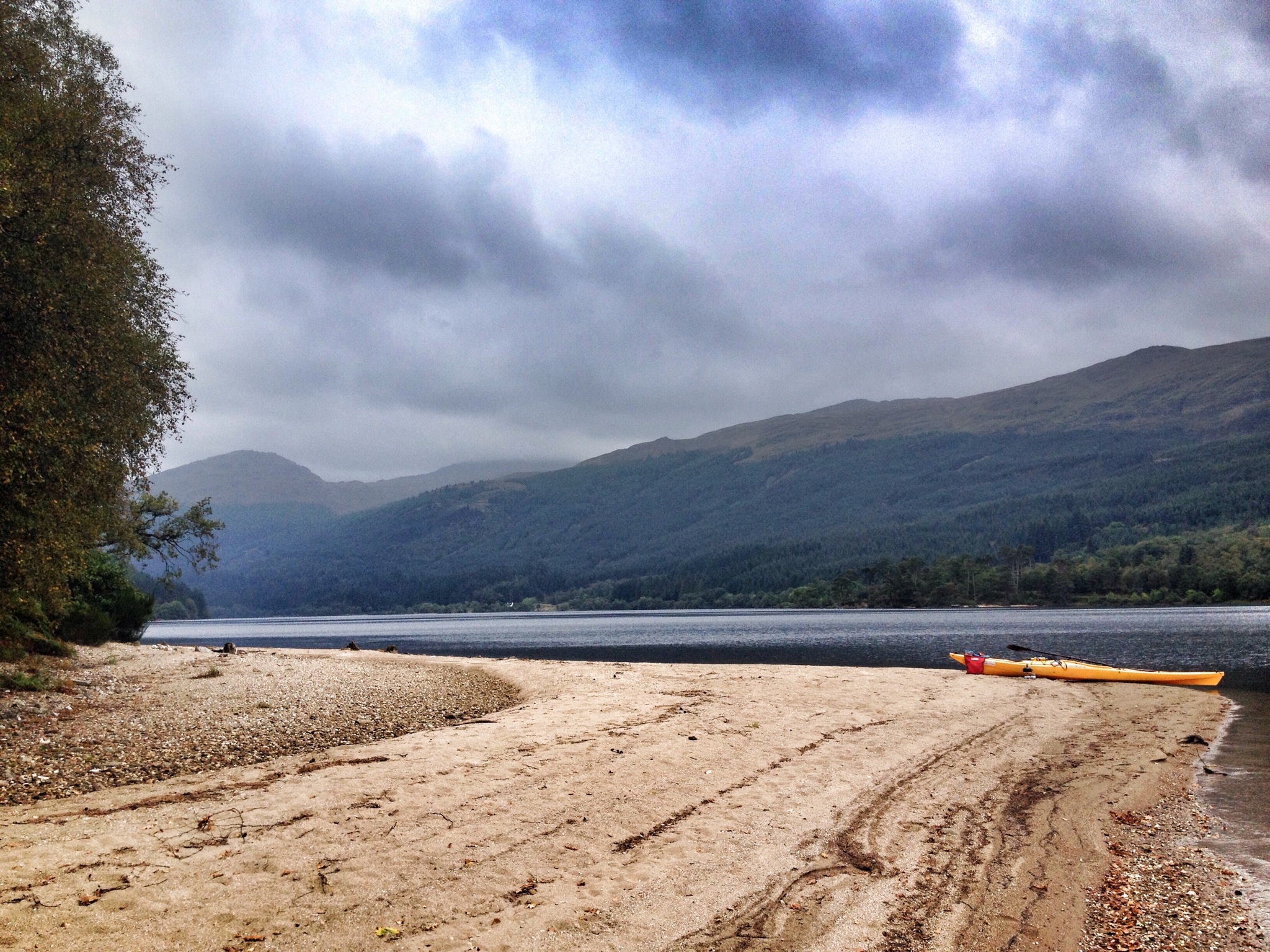
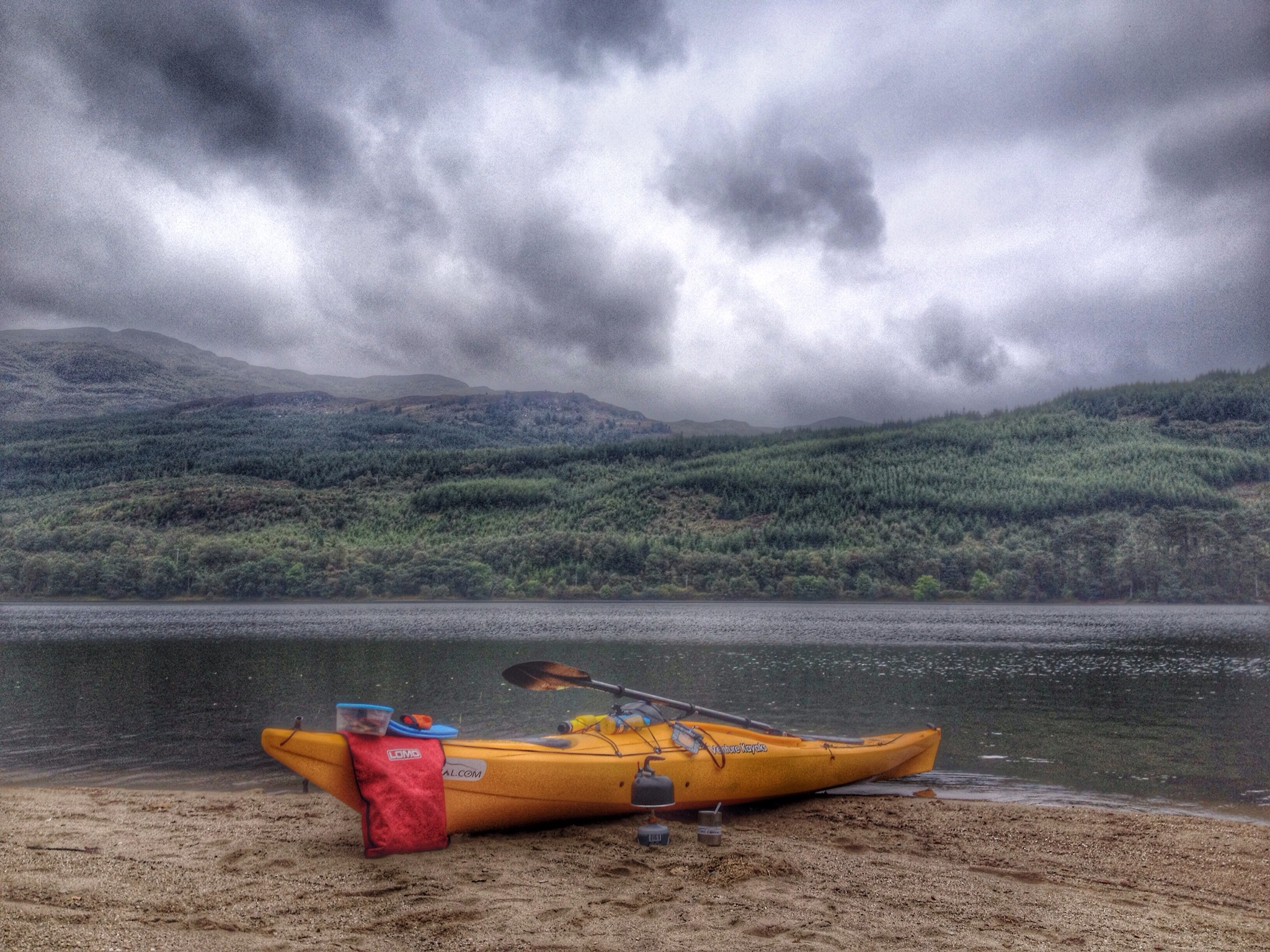
Had an afternoon off work, so managed to cover the south section of Route 26. Toward Hall to the link bridge in Bishops Glen,Dunoon. Works in at exactly 9.5 miles.
Got to Toward via a lift but there is a bus service that takes you to the start point.
Further route info available on an interactive map with Route,Statistics and Pictures, click below.
Interactive map HERE.
Pictures from walk,due to light and conditions pictures aren’t the best but give an idea of views and route.
9.5 to 17.65 miles
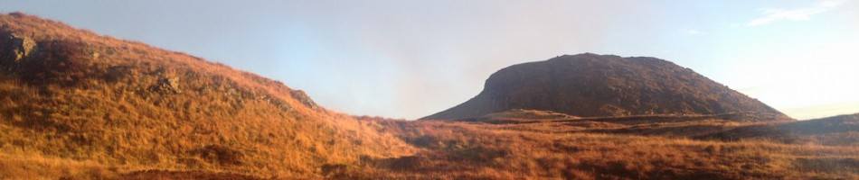
A wet and windy Sunday morning! Might as well record some of the route in the worst conditions!!
Started off where section 1 finished at the link bridge at the Bishops Glen. This route takes in, Dunoon, Sandbank, Glenkin, Ballochyle, Lower Glenmassan and Benmore with lots to see ( weather permitting ).
Bridge to Bridge came in at 8.15 miles and took me 2hr 45mins, that’s including stopping for pics but little else in the conditions.
See below for pictures and interactive map.
Viewranger have made it possible to view pictures from the route rather than the track only. Clicking on the camera icon at each location should bring up a picture below the map. You can zoom in and out and pan round the map. Any feedback welcome on this mapping system.
I finally got round to recording the final section of route 26. This section starts off at Benmore Gardens and finishes at Glenbranter. A scenic loch side journey.
Once I’d figured out where the 26.2 accumulative total ended, I continued the loop of Loch Eck, decided to take the bike for this section so I could get the miles in.
The mathematics were done,I needed 8.55 miles to get the the 26.2 from the bridge at Benmore. Now,whilst it’s not an exact science but this distance brought me to a forestry gate,right in front of Glenshellish farm……an excellent finishing point.
Interactive map with pictures can be found by clicking HERE. It’s for the full Loch Eck Loop but details the western flank of the loch for Route 26. Could always continue and make the route an Ultra!! (38.5ish miles).
There marks the end of Route 26. Its an extra half mile to the Forestry Commissions office.
Now just to piece it all together in one run and report back.
Some scenic footage of sections 2 & 3. Dunoon to Glenbranter.
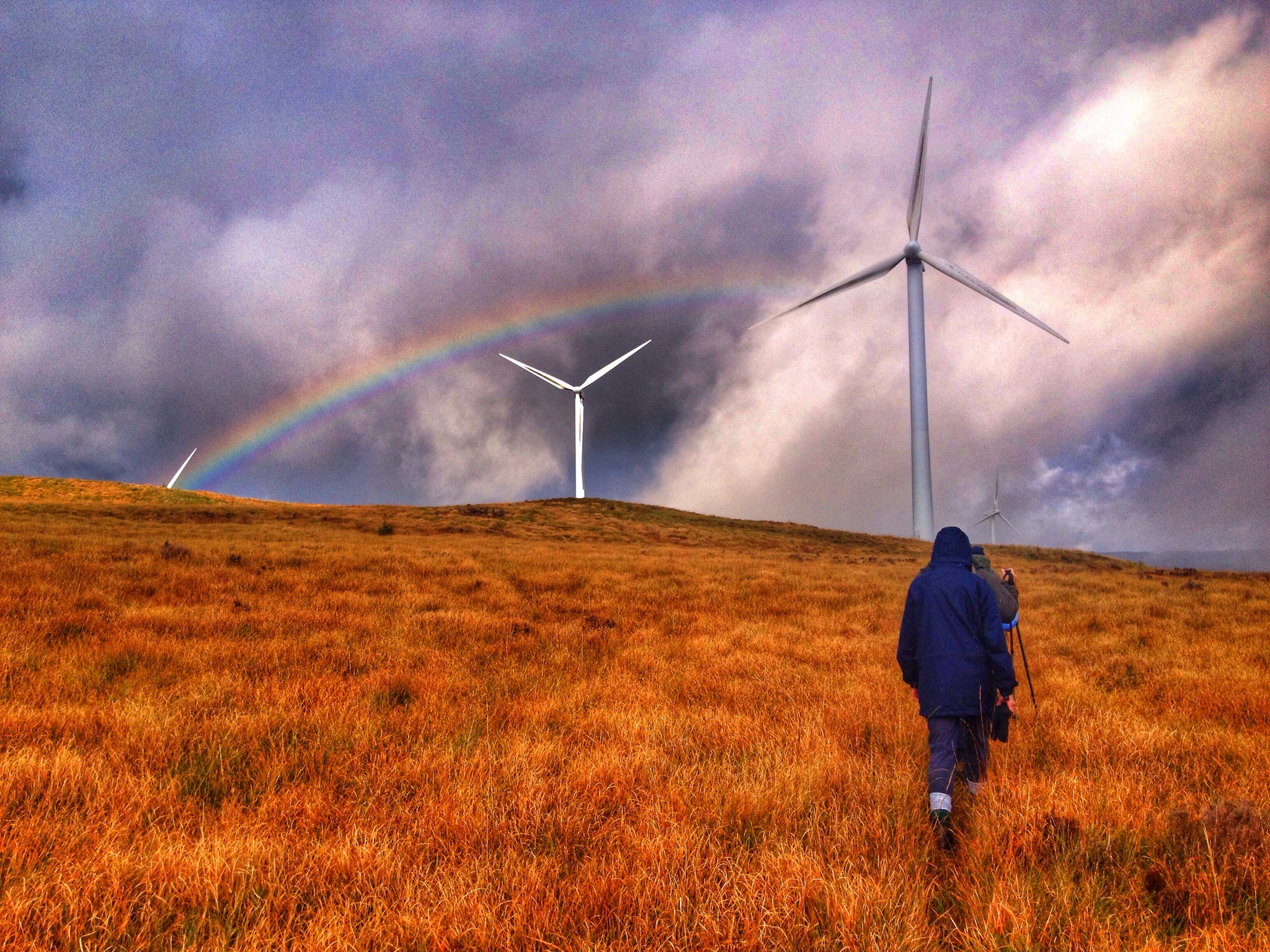
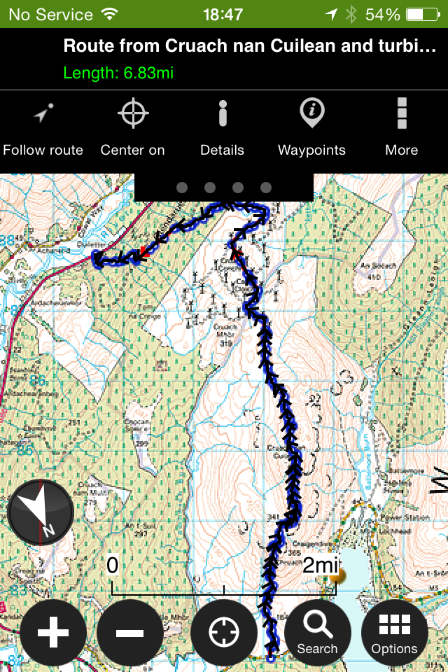
This time setting off from the B836 heading to Cruach nan Cuilean and over to Cruach Mhor wind farm in Glendaruel. I’ve visited both the hill and the wind farm but never tied the two together,so today was an excellent opportunity to do so. Our guide for today was Jim Campbell from Bute,who knows the area very well.
Conditions were not ideal due to the low cloud on the hill reducing any views to zero,but it was calm and dry for the majority of the walk so I’ll settle for that. Terrain,open hillside following deer paths,sheep paths and joining anything in between.
Interactive map with stats and pictures can be found by clicking HERE You can zoom in and see what part of the route the pictures were taken.
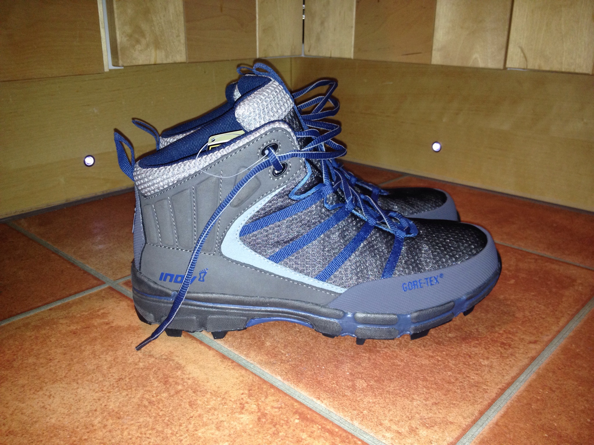
Introducing my latest purchase, the Inov8 Roclite 390 GTX. A lightweight (760gms on the kitchen scales) pair of mid boots with a Gore-Tex lining.
Justifying this purchase, I’m going for the fact that these are more than half the weight of my current boots (1600gms, 4 season Brashers).
Ok, the Inov8’s aren’t full on 4 season boots but I’m sure with the right socks they’ll mange in the colder seasons on lower level treks……maybe beyond.
I’ve been covering quite a lot of hardcore paths lately and the Brashers with their stiff sole (crampon compatible ) are not the best choice, but my only boot…..until now.
That’s me justified to myself, now to convince the wife!!!
Initial impression….definitely light, a good fit and what seems like good support despite the Mid height.
Will update this post as I put them to task.
Well,so far……..
Covered a walk of 7 miles, 5 of that on open hillside with no tracks. Wet underfoot,but the boots held out keeping feet dry. No issues with support over uneven ground.
Another walk, covering 11 miles of forestry road. Thinking the minimalist boots and sole would feel every stone on the road, but this wasn’t the case. Surprisingly fresh after the walk with no aches or pains. Certainly notice the lighter boots over longer distances.
Today was my first ever ‘Cowalfest’ walk, guided by John Ferguson.
John
A walk I’ve been wanting to do for years but never had the time or quite sure of an exact route.
Six keen walkers turned up to be guided to the crash site of the B29 Bomber. The Flying Fortress came down after clipping a nearby summit due to whats is thought to have been icing of the wings. This was back in 1949.
The walk it’s self was great…..forest roads, tracks, burn crossings, waterfalls, open hillside and that all important crash site.
Below are photos taken en route to the crash site,the site it’s self and a few returning via the same route.
John
A big thanks to John and Robert for their guidance on the walk and the organisers of Cowalfest.
Fully interactive map of route along with stats and locations of where pictures were taken. Click HERE
“Cowalfest offers a 10 day festival during October. This annual Walking and Outdoors Festival is one of the largest and most varied walking festivals in Scotland, with more than 80 walks led by expert and knowledgeable walk leaders.”
Cowalfest started today and tomorrow I’m taking part and joining a walk to Succothmore……….
“This walks starts with a short forestry section then opens out onto farmland, followed by a lovely glen walk. A hidden waterfall is passed before the ascent on a rough track beside another waterfall, which leads to higher ground with extensive views of Strachur and Loch Goil and visit the site where an American airplane crashed in 1949.”
Sounds like a walk with lots to see!!
Pics and wee report on my return.
Plenty of other walk and activities on this week, check out the website, click here for further details.
Over the last few day’s I’ve been playing about with the Viewranger App on my iPhone. I tended to use it for measuring distances whilst route planning and plotting my position when on the hill. However on looking at other trip logs I noticed people adding pictures to their tracks……………this I had to try.
Please see below links for details of my two trials. As well as pictures it goes into great detail when it comes to statistics…..I like numbers!
Just been selected to test out a new app/software for iOS on behalf of Viewranger. Should be interesting as I use the current version and it’s impressive as it is.


")
")
")
")
")
")
")
")
")
")
")
")
")
")
")
")
")
")
")
")
")
")
")
")
")
")
")
")
")
")
")
")
")
")
")
")
")
")
")
")
")
")
")
")
")
")
")
")
")
")
")

")
")
")
")
")
")
")
")
")
")
")
")
")
")
")
")
")
")
")
")
")
")
")
")
")
")
")
")
")
")
")
")
")
")
")
")
")
")
")
")
")
")
")
")
")
")
")
")
")
")
")
")
")
")
")
")
")
")
")
")
")
")
")
")
")
")
")

")

")
")
")
")
")
")
")
")
")
")
")
")
")
")
")
")
")
")

")
")
")
")
")
")
")
")
")
")
")
")
")
")
")
")
")
")
")
")
")
")
")
")
")
")
")
")
")
")
")
")
")
")
")
")
")
")
")
")
")
")
")
")
")
")
")
")
")

")
")
")
")
")
")
")
")
")
")
")
")
")
")
")
")
")
")
")
")
")
")
")
")
")
")
")
")
")
")
")
")
")
")
")
")
")
")
")
")
")
")
")
")
")
")
")
")
")
")
")
")
")
")
")
")
")
")